| |
|
|
|
|
|
Star System Sol - Planet Mars: The Red Planet

Above: Mars modeled in Pov-Ray using an image map courtesy of NASA.
All planet graphics were rendered in Pov-Ray using image maps of Mars provided courtesy of NASA JPL.

Above and below: a simulated Mars-scape, modeled in Pov-Ray. This view is of a crater rim from a crater floor.


North polar view.

South
polar view

Mars,
the Red Planet is aptly named as it is a cold desert world covered
in red-brown rust-colored sands rich in oxidized iron. In short,
loosely speaking, Mars is covered with powdered rust. Its red color
led to its mythical association with the Roman god of war, Mars.
Planet type: terrestrial, cold desert
planet.
Equatorial
Diameter:
6795 km.
Mass: 0.107 Earth masses.
Surface
gravity:
0.376 g.
Orbit: Mars orbits Sol at
1.38-1.67 astronomical units with a year lasting 686.98 Earth days
and a day length of 24 hours and 37.4 minutes.
Atmosphere: Thin, low pressure (about
0.007 times the pressure of Earth's atmosphere). An ionosphere is
present at 100-300 km. Mars has a diverse cloud system.
Surface
Temperature:
night-time temperatures: -140 degrees C, daytime temperatures rarely
rise above zero degrees C, though may reach 20 C in summer.
Magnetic
Field:
weak (about 0.2% of the Earth's), Mars has no radiation belts.
Life: none as yet discovered.
Although the surface is too dry and blasted by ultraviolet rays,
there may be liquid water and life beneath the planet's surface.
Some
key tourist attractions:
Sand
dunes
Active
sand dune-fields are abundant on Mars, for example those that
surround the North polar cap, and visible in the images above as
dark regions around the cap. These dunes are taller relative to the
distance between successive dunes than on Earth. Ripples six metres
tall have also been observed.
Dust
Devils
A
dust devil is a desert whirlwind that carries dust and is
accompanied by strong electric fields. Mars has much larger dust
devils than those found on Earth - Martian dust devils may be
several kilometres across and may reach the size of Mount Everest!
This compares to those on Earth which are typically about 10 metres
across and 100-200 metres tall. Martian dust devils are also
extremely common and criss-cross the planet's deserts on a daily
basis.
Above: A Martian Dust Devil - Click image to enlarge
Global
Dust Storms
Not
only are dust devils enormous and frequent on Mars, but dust storms
are also much more vast - in fact they are frequently global and
shroud the whole planet in dust for about a month at a time. These
vast storms only require a single day to develop. Dust particles
have reached recorded speeds of 100-160 kilometres per hour (60-100
miles per hour) in such storms. It is hard to explain all this
aluvial activity on a planet that has a thin atmosphere, but the
dust may be very fine and it is hypothesised that it may also be
driven into the planet's atmosphere by a build up of electric
charge, since Mars has no thunderclouds to dissipate excess charge
electricity must dissipate in other ways. Debate continues as to
what drives dust devils and dust storms - the wind or the electric
charge, or both.
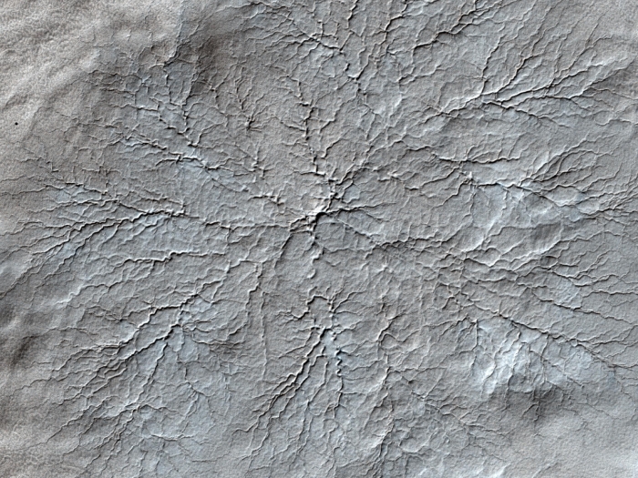
Carbon
Dioxide Geysers
The
ice caps of Mars contain both water ice and frozen carbon dioxide.
In summer the carbon dioxide ice thaws and in winter frost deposits
more frozen carbon dioxide. Recrystallisation of this deposited
carbon dioxide is thought to sort the particles, causing dust
trapped in the ice to slowly sink downwards, leaving a top layer of
clear ice about one metre deep. This is thought to act like a lens,
magnifying the Sun's light and heating the underlying soil. This
causes carbon dioxide gas to build up beneath the ice layer.
Eventually this gas escapes through vents in the ice as geysers that
jet hundreds of metres into the atmosphere. Heavier darker material
gets blasted out with the gas and this material falls back down and
deposits to form a cone around each vent with dark downwind streaks.
The gas tends to escape through the same vent sites each summer, and
beneath the ice river-like channels are excavated in the soil by the
gas, forming a spider web of channels that radiate toward each vent.
Valles
Marineris Canyon System
This
vast equatorial canyon system measures 4500 km from east to west and
150 to 700 km from north to south. Individual canyons may be up to
200 km wide and 7 km deep. This makes Earth's Grand Canyon look tiny
(at 28 km maximum width and 2 km depth).

Click on the image above to see the position of the Valles Marineris canyon system (outlined).
Olympus
Mons Volcano
The
largest volcano on Mars, Olympus Mons is more than 600 km wide at
its base and terminates in a 90 km caldera at an altitude of 26 km.
This dwarfs Earth's largest volcano, Mauna Kea, Hawaii, which is 120
km wide at its base and 9.3 km high.
Dry
River Beds
Mars
apparently once had plenty of liquid water running freely over its
surface, since many dried-up river channels still meander across its
surface and sedimentary rocks that formed in water are to be found.
Recently new streams of liquid, probably water, have been discovered
that flow momentarily across the surface of Mars after springing
forth from slopes (crater rims, hills etc.). This adds weight to the
hypothesis that Mars contains a subsurface reservoir of liquid
water. It is already known that layers of water ice exist beneath
the Martian surface, but evidence suggests that further down there
may be liquid water. Also, methane has been detected in the Martian
atmosphere, which presumably came from beneath the planet's surface
by some out-gassing process. This methane could be of geochemical or
biological origin. It is looking as if conditions on Mars are
suitable for several forms of life on Earth, but whether or not life
has actually evolved or currently exists on Mars is still unknown.

Above: a dry river channel on Mars, in Terra Sabaea near Hellas Planitia; note the meanders; courtesy of NASA/JPL-Caltech/Arizona State University; https://www.jpl.nasa.gov/images/channel-13
Meanders form in flowing fluids such as rivers, whether they are rivers of water, lava or gas. However, melt-water streams on glaciers and air in the Jet Stream all meander. This suggests that sediment erosion and deposition do not cause meanders (though they do modify the final pattern) and it is thought that meanders happen because of the intrinsic properties of the fluid flow, independent of external forces. (Rain drops running down a pane of glass, hosepipes and blood capillaries also develop sinuous forms, though it is not clear whether this is by the same mechanism). The sinuosity of a river channel is its actual path length measured along the channel itself divided by the distance traveled downstream (L/X in the diagram below, where L is the actual river length following the contours). A perfectly straight channel has a sinuosity of 1.0. We can (somewhat arbitrarily) consider a channel with a sinuosity above 1.5 as meandering.

Above: the anatomy of a meander, showing one complete cycle over one meander wavelength (lambda, λ). This is sometimes called 'meander length' but this is a confusing usage. The wavelength of a meander is proportional to channel width. Studies have found that meander wavelength is usually between 7 and 10 times the channel width, with successive crossover points occurring every 5 to 7 channel widths. (Measured along the channel itself, that is along the path s in the above diagram, one complete meander cycle occurs every 5 to 7 channel widths). The actual constant of proportionality depends on study region and so is clearly affected by other variables.
The amplitude of meanders also correlates with channel width, but the correlation is weaker in this case. It has been shown that sinuosity correlates with the cohesiveness of materials making up the banks and bed (channel boundaries) and also homogeneity of the material. Deep and narrow rivers also tend to be more sinuous. Thus, in contrast to meander wavelength, amplitude seems more dependent on substrate and erosion than on intrinsic hydrodynamic factors.
The path of the river is described by the parameter s, with s going from 0 to the actual channel length L. The angle of curvature, θ, is given as a function of distance along the channel, s/L, and the geometry of meanders is well described empirically by the sinusoidal function given.
The actual geometry depends on θ0 as illustrated below:
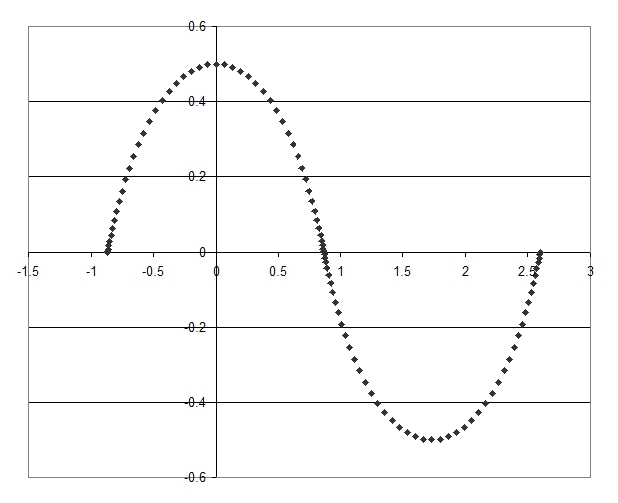
Above: For the angle at crossover, θ0 = 60 degrees.
(Note: the position of the origin along the x-axis is arbitrary).

Above: For the angle at crossover, θ0 = 120 degrees.
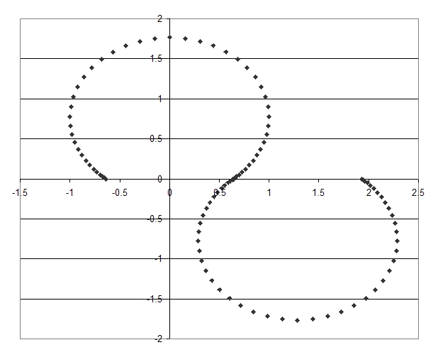
Above: For the angle at crossover, θ0 = 140 degrees.
It should be borne in mind that meanders are not always static but often migrate downstream slowly with time by a combination of sediment erosion and deposition (which must occur but are almost certainly not the principle causes of meander migration). Meanders may also increase in amplitude with time, with the meander loops getting cut off as the meanders migrate downstream. Meander loops may also rotate.
The precise mechanism by which meanders form is not fully understood. As explained, the formation of meanders is driven by intrinsic properties of flowing fluid, though of course for a channel cut into a substrate, the substrate must be moved by erosion and deposition to allow meanders to form. One model of meander formation is as follows (Da Silva, 2005). Friction between the flowing fluid and the channel banks and bed generates vortices. These bursts of vortices are shed into the mainstream where they coalesce into large coherent structures. From the bank, horizontal vortices form, coalesce and migrate to the opposite bank where they lose energy and dissipate into low energy fluid that returns to the original bank where it may possibly trigger more vortex formation. Similarly, from the bed vertical vortices are generated which migrate to the free surface, dissipate and then this flow return to the river bed. These horizontal and vertical vortices combine to form helical secondary flow which is thought to trigger meander formation (if the river was in an enclosed channel it might have a tendency to form a helix?).
Deposits on the river bed called riffles tend to form in the straight regions between meander loops whilst excavations called pools occur on the bed at meander bends. This is the riffle-pool sequence. Riffles are a type of bar, point-bars also develop where material is deposited on the inside bank of a meander bend (whilst the outside bank of a bend is being eroded). The bed material may also develop smaller ripples (in gentle flow with fine material) or dunes (larger than ripples, form in more forceful flow). Antidunes are dune-like structures formed by the action of surface waves.
One of the aims of planetary scientists is to understand channel formation on other planets and compare their geometry and geology to river channels on Earth. Channels can transport fluids other than water, such as lava channels on mars and Venus, which also meander, and gas channels, such as those that develop beneath carbon dioxide ice on Mars as the ice sublimates the gas carves channels in the substrate beneath the overlying ice mass.
Above: erosion channels formed by sublimating carbon dioxide near the south pole of Mars; courtesy of NASA/JPL-Caltech/Arizona State University; https://www.jpl.nasa.gov/images/erosion-features-near-the-south-pole-of-mars

Above: the Eberswalde Delta on Mars. This is a fossilized river delta where a river flowed into a lake : sediments deposited as the river dried long ago have consolidated into rock. erosion of the surrounding bed leaves the delta visible as an 'inverted channel'. Image courtesy of NASA/JPL-Caltech/Arizona State University; https://www.jpl.nasa.gov/images/eberswalde-delta-in-high-resolution

Equatorial View: mars is tilted on its axis by 25.19 degrees.

North Polar View
References / Further Reading
Da Silva, A.M.F. 2005. meanders - on why and how do rivers meander. 14th IAHR Arthur Thomas Ippen Award Lecture, XXXI IAHR Congress, Seoul, South Korea, September 2005. (Available on academia.edu).
Article
updated:
4th Sep 2015
5th Sep 2015
22 May 2021